
1967 Map of Pittsburg
USGS Topo · Published 1968About this map
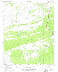
Pittsburg serves as the primary hub in this late 1960s topographic study, situated just north of the prominent Limestone Ridge. The landscape is defined by the sharp transition from the flat agricultural lands and rail corridors to the north into the series of parallel ridges including Kiowa Mountain and Pine Mountain. Industrial history is etched into the terrain via an Old Grade railroad bed and a specific Mine location northwest of Storrie Lake, reflecting the region's extractive past.
Find a feature on this map
21 named features on this map. Tap any name to fly to it.
Don’t see what you’re looking for? This feature index may not catch every label — zoom into the map to look around manually.
Map Details
Editions of this 1967 Pittsburg Map
2 editions found
Other maps of this area

1898 · McAlester
USGS Topo · 1:125,000

1909 · Mc Alester
USGS Topo · 1:125,000

1950 · Mcalester
USGS Topo · 1:250,000

1957 · Limestone Gap
USGS Topo · 1:24,000

1962 · McAlester
USGS Topo · 1:250,000

1965 · McAlester
USGS Topo · 1:250,000
1967 · Mc Alester SW
USGS Topo · 1:24,000
1967 · Kiowa
USGS Topo · 1:24,000

1967 · Hartshorne SW
USGS Topo · 1:24,000
1967 · Savanna
USGS Topo · 1:24,000