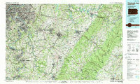
1986 Map of Pittsburgh East
USGS Topo · Published 1988About this map
Industrial river valleys and the ridges of the Allegheny Plateau define this 1980s landscape east of Pittsburgh. The confluence of the Allegheny River and Monongahela River gives way to a dense network of mill towns and coal-belt boroughs, including McKeesport, Duquesne, and Clairton. Moving east, the terrain rises toward Chestnut Ridge and Laurel Hill, revealing the transition from heavy industry to the timbered reaches of Forbes State Forest.
Find a feature on this map
69 named features on this map. Tap any name to fly to it.
Don’t see what you’re looking for? This feature index may not catch every label — zoom into the map to look around manually.
Map Details
Editions of this 1986 Pittsburgh East Map
3 editions found
Other maps of this area

1900 · Uniontown
USGS Topo · 1:62,500

1900 · Masontown
USGS Topo · 1:62,500

1900 · Latrobe
USGS Topo · 1:62,500

1901 · Amity
USGS Topo · 1:62,500

1901 · Waynesburg
USGS Topo · 1:62,500

1902 · Latrobe
USGS Topo · 1:62,500

1902 · Indiana
USGS Topo · 1:62,500

1902 · Brownsville
USGS Topo · 1:62,500

1902 · Connellsville
USGS Topo · 1:62,500

1902 · Barnesboro
USGS Topo · 1:62,500