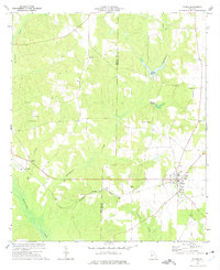
1973 Map of Plains
USGS Topo · Published 1975About this map
Plains serves as the focal point of this agricultural landscape in Sumter and Webster Counties during the early 1970s. The settlement pattern is defined by the Seaboard Coast Line railroad, which tracks east-to-west through the small communities of Archery and Dumas. The map reveals a deeply rooted rural society, evidenced by the high density of country churches and family burial grounds including Mt Avery Ch, Lebanon Cem, and the Tabernacle Ch.
Find a feature on this map
26 named features on this map. Tap any name to fly to it.
Don’t see what you’re looking for? This feature index may not catch every label — zoom into the map to look around manually.
Map Details
Editions of this 1973 Plains Map
2 editions found
Other maps of this area

1953 · Dothan
USGS Topo · 1:250,000

1954 · Dothan
USGS Topo · 1:250,000

1955 · Dothan
USGS Topo · 1:250,000

1955 · Phenix City
USGS Topo · 1:250,000

1957 · Phenix City
USGS Topo · 1:250,000

1958 · Phenix City
USGS Topo · 1:250,000
1972 · Preston
USGS Topo · 1:24,000

1972 · Parrott
USGS Topo · 1:24,000

1972 · Ellaville South
USGS Topo · 1:24,000
1973 · Church Hill
USGS Topo · 1:24,000