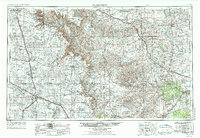
1954 Map of Plainview
USGS Topo · Published 1976About this map
Palo Duro Canyon and the surrounding High Plains of the Texas Panhandle define this mid-century survey. The landscape is dominated by the dramatic escarpment of the Caprock, where the Prairie Dog Town Fork Red River and Tule Canyon carve deep into the plateau. This era shows a well-developed agricultural and transportation network, with the Fort Worth and Denver and Panhandle and Santa Fe railroads connecting established ranching and farming hubs like Plainview, Childress, and Canyon. The map captures the distinctive drainage patterns of the Llano Estacado, featuring numerous ephemeral draws such as Running Water Draw and the various branches of South Tule Draw, which supported early settlement and irrigation. Within Palo Duro State Park, the terrain drops sharply from the flat plains, providing a stark contrast to the grid-like road system that services smaller communities like Silverton, Quitaque, and Happy.
Find a feature on this map
51 named features on this map. Tap any name to fly to it.
Don’t see what you’re looking for? This feature index may not catch every label — zoom into the map to look around manually.
Map Details
Editions of this 1954 Plainview Map
3 editions found
Other maps of this area

1927 · Quanah 3-b
USGS Topo · 1:48,000

1932 · Vivian
USGS Topo · 1:62,500

1954 · Lubbock
USGS Topo · 1:250,000

1954 · Tucumcari
USGS Topo · 1:250,000

1954 · Amarillo
USGS Topo · 1:250,000

1954 · Plainview
USGS Topo · 1:250,000

1954 · Wichita Falls
USGS Topo · 1:250,000

1954 · Clovis
USGS Topo · 1:250,000

1954 · Brownfield
USGS Topo · 1:250,000

1955 · Lawton
USGS Topo · 1:250,000