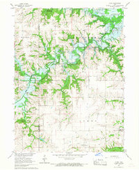
1966 Map of Plano
USGS Topo · Published 1967About this map
The South Fork Chariton River and its numerous tributaries dominate this mid-1960s landscape, just as major hydrological changes were beginning. This survey was conducted during the development of the Rathbun Reservoir, with blue hatching clearly indicating large sections of the river valley destined to be submerged at a Normal Pool Elevation 904. The map serves as a vital record for genealogists, preserving the locations of rural landmarks like Philadelphia Ch and Philadelphia Cem before the local geography was altered by the rising waters.
Find a feature on this map
26 named features on this map. Tap any name to fly to it.
Don’t see what you’re looking for? This feature index may not catch every label — zoom into the map to look around manually.
Map Details
Editions of this 1966 Plano Map
This is the sole edition of this map. No revisions or reprints were ever made.
Other maps of this area

1935 · Russell
USGS Topo · 1:62,500

1938 · Russell
USGS Topo · 1:62,500

1939 · Centerville
USGS Topo · 1:62,500

1939 · Mystic
USGS Topo · 1:62,500

1941 · Centerville
USGS Topo · 1:62,500

1942 · Mystic
USGS Topo · 1:62,500

1942 · Seymour
USGS Topo · 1:62,500

1944 · Seymour
USGS Topo · 1:62,500

1954 · Centerville
USGS Topo · 1:250,000

1957 · Centerville
USGS Topo · 1:250,000