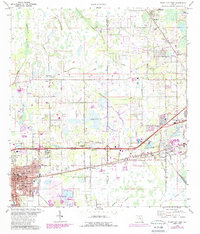
1975 Map of Plant City East
USGS Topo · Published 1987About this map
Plant City and its surrounding communities are captured here during a period of transition as phosphate mining and agricultural land-use evolved in Central Florida. The landscape is defined by the drainage of Itchepackesassa Creek and Blackwater Creek, interspersed with wetlands and the open expanse of Wiggins Prairie. Modern development and industrial growth are evident near the CSX rail corridor, while large-scale land modification is visible in the southern portion of the map at the Reclaimed Strip Mine. The map shows a high concentration of institutional landmarks, including Hillsborough Community College and several local schools like Marshall High Sch. Genealogists and local historians will find significant detail in the presence of established burial grounds like Garden of Peace Cem and Oaklawn Cem, alongside numerous country churches such as Good Shepherd Ch and Springhead Ch.
Find a feature on this map
47 named features on this map. Tap any name to fly to it.
Don’t see what you’re looking for? This feature index may not catch every label — zoom into the map to look around manually.
Map Details
Editions of this 1975 Plant City East Map
3 editions found
Other maps of this area

1944 · Plant City
USGS Topo · 1:31,680

1944 · Providence
USGS Topo · 1:31,680

1944 · Lakeland
USGS Topo · 1:31,680

1944 · Antioch
USGS Topo · 1:31,680

1944 · Socrum
USGS Topo · 1:31,680

1947 · Zephyrhills
USGS Topo · 1:24,000

1949 · Mulberry
USGS Topo · 1:24,000

1950 · Mulberry
USGS Topo · 1:24,000

1955 · Nichols
USGS Topo · 1:24,000

1955 · Dover
USGS Topo · 1:24,000