
2024 Map of Playa De Ponce
USGS Topo · Published 2024About this map
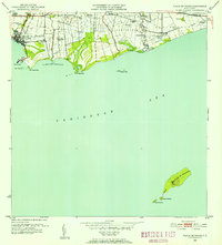
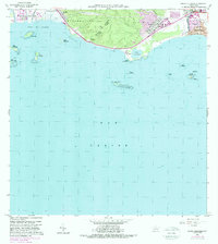
Ponce serves as the focal point of this coastal survey, where the urban landscape meets the Caribbean Sea. The map details the transition from the city's academic and legal hubs, such as the Universidad de Puerto Rico en Ponce and the Centro Judicial de Ponce, toward the industrial and maritime infrastructure of Playa de Ponce. The shoreline is characterized by a series of points and islets, including Punta Peñoncillo and the Gata Islets, which protect the Bahia de Ponce and the busy Muelle de Ponce.
Find a feature on this map
44 named features on this map. Tap any name to fly to it.
Don’t see what you’re looking for? This feature index may not catch every label — zoom into the map to look around manually.
Map Details
Editions of this 2024 Playa De Ponce Map
This is the sole edition of this map. No revisions or reprints were ever made.
Historical Maps of Vayas Through Time
19 maps found

1945 Playa De Ponce
Ponce Municipio, PR

1946 Punta Cuchara
Ponce Municipio, PR

1947 Adjuntas SE
Ponce Municipio, PR

1947 Jayuya SO
Ponce Municipio, PR

1947 Penuelas NE
Ponce Municipio, PR

1947 Penuelas SE
Ponce Municipio, PR

1947 Playa De Ponce NO
Ponce Municipio, PR

1947 Ponce NO
Ponce Municipio, PR

1947 Ponce SO
Ponce Municipio, PR

1947 Punta Gughara NE
Ponce Municipio, PR
1952 Playa De Ponce
Ponce Municipio, PR

1952 Punta Cuchara
Ponce Municipio, PR

1958 Playa De Ponce
Ponce Municipio, PR

1958 Punta Cucharas
Ponce Municipio, PR

1962 Playa De Ponce
Ponce Municipio, PR
1962 Punta Cucharas
Ponce Municipio, PR
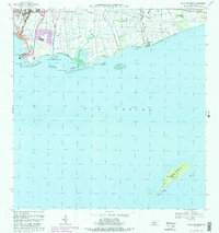
1970 Playa De Ponce
Ponce Municipio, PR
2024 Playa De Ponce
Ponce Municipio, PR

2024 Punta Cucharas
Ponce Municipio, PR