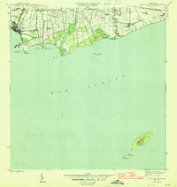
1945 Map of Playa De Ponce
USGS Topo · Published 1945About this map
Sugar production and maritime trade define the coastal landscape of southern Puerto Rico in the mid-1940s. The shoreline is anchored by the Playa de Ponce and its critical Muelle de Ponce, where the industrial infrastructure of the American Railroad meets the Caribbean Sea. Inland, the agricultural economy is dominated by large estates and processing facilities including Central Constancia, Central Fortuna, and Central Boca Chica. A series of family-named agricultural estates, such as Hacienda Estrella and Hacienda Santa Cruz, are distributed between the courses of the Río Portugués and Río Inabón. Farther offshore, the survey detail extends to Isla Caja de Muertos, featuring Cerro Morrillo and La Hamaca. This survey documents the transition of the Ponce region during an era of significant industrial and agricultural coordination.
Find a feature on this map
34 named features on this map. Tap any name to fly to it.
Don’t see what you’re looking for? This feature index may not catch every label — zoom into the map to look around manually.
Map Details
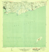
Editions of this 1945 Playa De Ponce Map
3 editions found
Other maps of this area

1944 · Santa Isabel
USGS Topo · 1:30,000

1945 · Playa De Ponce
USGS Topo · 1:30,000

1945 · Ponce
USGS Topo · 1:30,000

1945 · Rio Descalabrado
USGS Topo · 1:30,000

1946 · Punta Cuchara
USGS Topo · 1:30,000

1946 · Penuelas
USGS Topo · 1:30,000
1947 · Playa De Ponce NE
USGS Topo · 1:10,000

1947 · Punta Gughara NE
USGS Topo · 1:10,000

1947 · Ponce SO
USGS Topo · 1:10,000
1947 · Ponce SE
USGS Topo · 1:10,000