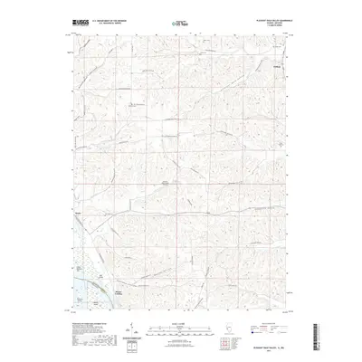
2021 Map of Pleasant Dale Valley
USGS Topo · Published 2021About this map
Mozier Landing and the riverfront settlement of Mozier occupy a narrow shelf between the bluffs and the Mississippi River in this western Illinois landscape. The interior is defined by deep, winding drainages like Pleasant Dale Valley and Bess Hollow, the latter of which features the Herrens Bess Hollow Airfield. Local genealogy is well-documented through numerous family and community burial grounds, including Hillcrest Cem, Retzer Cem, and Fox Creek Cem, often located on high ground overlooking the hollows. Further north, the community of Cliffdale sits near the head of the valley system. The terrain is marked by distinct river features such as Thomas Chute and Dog Island, illustrating the complex relationship between the waterway and the agrarian uplands of Calhoun and Pike counties.
Find a feature on this map
61 named features on this map. Tap any name to fly to it.
Don’t see what you’re looking for? This feature index may not catch every label — zoom into the map to look around manually.
Map Details
Editions of this 2021 Pleasant Dale Valley Map
This is the sole edition of this map. No revisions or reprints were ever made.
Other maps of this area

1930 · Pearl
USGS Topo · 1:62,500

1930 · Nebo
USGS Topo · 1:62,500

1930 · Hardin
USGS Topo · 1:62,500

1934 · Nebo
USGS Topo · 1:48,000

1934 · Elsberry
USGS Topo · 1:48,000

1934 · Hardin
USGS Topo · 1:62,500

1938 · Hardin
USGS Topo · 1:62,500

1942 · Nebo
USGS Topo · 1:62,500

1942 · Elsberry
USGS Topo · 1:62,500

1948 · Quincy
USGS Topo · 1:250,000