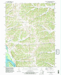
1993 Map of Pleasant Dale Valley
USGS Topo · Published 1996About this map
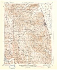
The Mississippi River and Illinois River converge near this stretch of Calhoun County, creating a landscape defined by deep drainage hollows and narrow ridges. Small river-oriented settlements like Mozier and the outskirts of Kampsville are documented here in the early 1990s, along with family and community landmarks such as Hillcrest Cem and Smith Cem. The topography is etched by numerous watercourses including Fox Creek, Silver Creek, and the eponymous Pleasant Dale Valley Creek, which has carved a significant valley through the limestone-rich terrain. Historical land use is evident in the presence of a Quarry and Gravel Pit, while the river's ecological importance is reflected in the Upper Mississippi River State Conservation Area and named river features like Mozier Island and Dog Island.
Find a feature on this map
36 named features on this map. Tap any name to fly to it.
Don’t see what you’re looking for? This feature index may not catch every label — zoom into the map to look around manually.
Map Details
Editions of this 1993 Pleasant Dale Valley Map
This is the sole edition of this map. No revisions or reprints were ever made.
Other maps of this area

1930 · Pearl
USGS Topo · 1:62,500

1930 · Nebo
USGS Topo · 1:62,500

1930 · Hardin
USGS Topo · 1:62,500
1934 · Nebo
USGS Topo · 1:48,000
1934 · Elsberry
USGS Topo · 1:48,000

1934 · Hardin
USGS Topo · 1:62,500

1938 · Hardin
USGS Topo · 1:62,500
1942 · Nebo
USGS Topo · 1:62,500
1942 · Elsberry
USGS Topo · 1:62,500

1948 · Quincy
USGS Topo · 1:250,000