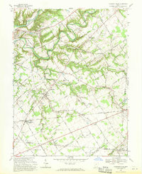
1968 Map of Pleasant Plain
USGS Topo · Published 1970About this map
The Little Miami River snakes across this Warren County landscape, separating historic land divisions including the Symmes Purchase and the Virginia Military District. In the northwest corner, the town of Morrow serves as a junction for the Penn Central railroad, while further south, the Baltimore and Ohio line passes through Pleasant Plain. The rural character of the late 1960s is defined by a high density of family-named cemeteries and small community anchors such as the Harlan Butlerville School and Sugar Run Church. Numerous small waterways like Todd Run and Second Creek carve through the terrain, with several notable hollows including Hicks Hollow and Steep Hollow providing varied relief. This survey documents a quiet period in southwest Ohio before modern suburban expansion, preserving the locations of rural nodes like Butlerville, Roachester, and Osceola.
Find a feature on this map
113 named features on this map. Tap any name to fly to it.
Don’t see what you’re looking for? This feature index may not catch every label — zoom into the map to look around manually.
Map Details
Editions of this 1968 Pleasant Plain Map
This is the sole edition of this map. No revisions or reprints were ever made.
Other maps of this area

1907 · Blanchester
USGS Topo · 1:62,500

1914 · Batavia
USGS Topo · 1:48,000

1914 · Morrow
USGS Topo · 1:62,500

1916 · Batavia
USGS Topo · 1:62,500

1916 · Morrow
USGS Topo · 1:62,500

1917 · Sardinia
USGS Topo · 1:62,500

1944 · Sardinia
USGS Topo · 1:62,500

1947 · Columbus
USGS Topo · 1:250,000

1953 · Goshen
USGS Topo · 1:24,000

1953 · Newtonsville
USGS Topo · 1:24,000