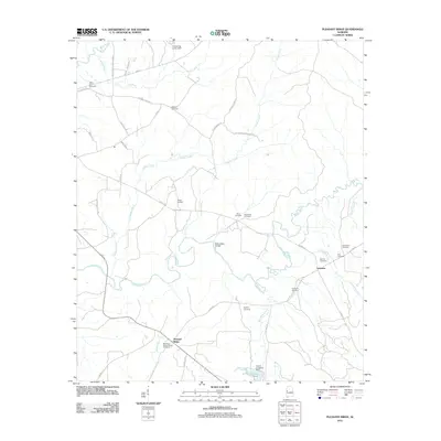
2011 Map of Pleasant Ridge
USGS Topo · Published 2011About this map
The Sipsey River meanders across this rural Greene County landscape, defining the character of a region marked by small settlements and family burial grounds. At the southern end, Pleasant Ridge serves as a focal point, featuring the Pleasant Ridge Church and Pleasant Ridge Cemetery. The network of county roads, including Co HWY-120 and Co HWY-119, connects dispersed historical sites like Lewiston and Wilder Quarters. Significant local infrastructure is noted by the Richardson Bridge and the Homer Carpenter Dam, which creates Carpenters Lake on Shambley Creek. Genealogy interest is high here, with numerous small cemeteries such as Bethany Cemetery, Eatman Cemetery, and Screptah Cemetery scattered throughout the river valley and its tributaries like Hughes Creek and Lubbub Creek. The map documents a traditional Southern agricultural and residential pattern where life is closely tied to the winding river and the long-established roads of the Alabama interior.
Find a feature on this map
43 named features on this map. Tap any name to fly to it.
Don’t see what you’re looking for? This feature index may not catch every label — zoom into the map to look around manually.
Map Details
Editions of this 2011 Pleasant Ridge Map
This is the sole edition of this map. No revisions or reprints were ever made.
Other maps of this area

1927 · Eutaw
USGS Topo · 1:48,000

1931 · Eutaw
USGS Topo · 1:62,500

1953 · Montgomery
USGS Topo · 1:250,000

1953 · Birmingham
USGS Topo · 1:250,000

1953 · Meridian
USGS Topo · 1:250,000

1953 · West Point
USGS Topo · 1:250,000

1956 · Birmingham
USGS Topo · 1:250,000

1956 · Montgomery
USGS Topo · 1:250,000

1957 · Birmingham
USGS Topo · 1:250,000

1957 · Meridian
USGS Topo · 1:250,000