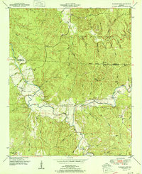
1951 Map of Pleasant Site
USGS Topo · Published 1951About this map
Pleasant Site and the rural hills of western Franklin Co are documented here in the early 1950s by the Tennessee Valley Authority and Geological Survey. The landscape is defined by the winding course of Cedar Creek, which is fed by numerous family-named drainages such as Ramsey Mill Branch, Starky Mill Br, and Wilson Mill Branch. These names suggest a legacy of early water-powered industry along the valley floors.
Find a feature on this map
49 named features on this map. Tap any name to fly to it.
Don’t see what you’re looking for? This feature index may not catch every label — zoom into the map to look around manually.
Map Details
Editions of this 1951 Pleasant Site Map
3 editions found
Other maps of this area

1925 · Barton
USGS Topo · 1:62,500

1926 · Barton
USGS Topo · 1:48,000

1929 · Barton
USGS Topo · 1:62,500

1935 · Pleasant Site
USGS Topo · 1:24,000

1936 · Belmont
USGS Topo · 1:24,000

1936 · Pleasant Grove
USGS Topo · 1:24,000

1936 · Red Bay
USGS Topo · 1:24,000
1936 · Barton
USGS Topo · 1:24,000

1936 · Halltown
USGS Topo · 1:24,000

1936 · Bishop
USGS Topo · 1:24,000