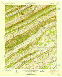
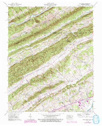
1939 Map of Plum Grove
USGS Topo · Published 1954About this map
Parallel ridges of Big Ridge, Copper Ridge, and Pine Mountain dominate this corner of the Appalachians along the Virginia and Tennessee border. This 1939 Tennessee Valley Authority survey captures a rural landscape organized by narrow valleys, where the Clinch River and Holston River serve as natural boundaries. Settled areas like New Canton and Flat Rock sit within these corridors, connected by the Lee Highway and the Southern railroad line.
Find a feature on this map
63 named features on this map. Tap any name to fly to it.
Don’t see what you’re looking for? This feature index may not catch every label — zoom into the map to look around manually.
Map Details
Editions of this 1939 Plum Grove Map
5 editions found
Other maps of this area

1892 · Greeneville
USGS Topo · 1:125,000

1894 · Estillville
USGS Topo · 1:125,000

1896 · Greeneville
USGS Topo · 1:125,000

1904 · Greeneville
USGS Topo · 1:125,000

1935 · Surgoinsville
USGS Topo · 1:48,000

1935 · Lovelace
USGS Topo · 1:24,000

1935 · Moggasin
USGS Topo · 1:48,000

1935 · Looneys Gap
USGS Topo · 1:24,000

1935 · Clinchport
USGS Topo · 1:24,000
1935 · Duffield
USGS Topo · 1:24,000