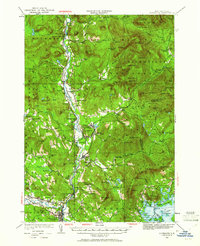
1928 Map of Plymouth
USGS Topo · Published 1961About this map
The Pemigewasset River corridor serves as the primary artery for settlement and industry in this 1928 survey, which captures the White Mountain region during a transitional era for timber and tourism. The Boston and Maine Railroad follows the river's winding path, connecting established hubs like Plymouth and Woodstock with small industrial and transit points such as Lyfords Siding and Beebe River. Local education and community life are well-documented through a network of rural schoolhouses, including Thornton Sch and Elm Sch, while the seasonal character of the region is evident in the Fairgrounds and the Waterville Forest Camp. To the east, the Sandwich Mountains dominate the terrain, featuring landmarks like Mt Tecumseh and Sachem Peak. This sheet is particularly valuable for genealogists tracing family names through the numerous hill-country school districts and small village centers.
Find a feature on this map
155 named features on this map. Tap any name to fly to it.
Don’t see what you’re looking for? This feature index may not catch every label — zoom into the map to look around manually.
Map Details
Editions of this 1928 Plymouth Map
5 editions found
Other maps of this area

1895 · Crawford Notch
USGS Topo · 1:62,500

1896 · Crawford Notch
USGS Topo · 1:62,500

1909 · Winnepesaukee
USGS Topo · 1:62,500

1925 · Holderness
USGS Topo · 1:62,500

1927 · Holderness
USGS Topo · 1:62,500

1927 · Cardigan
USGS Topo · 1:62,500

1928 · Plymouth
USGS Topo · 1:62,500

1928 · Rumney
USGS Topo · 1:62,500

1929 · Moosilauke
USGS Topo · 1:62,500

1929 · Franconia
USGS Topo · 1:62,500