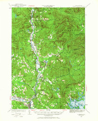
1928 Map of Plymouth
USGS Topo · Published 1967About this map
The Pemigewasset River valley serves as the central artery for this 1928 landscape, where small villages and industrial outposts are tied together by the Boston And Maine RR. At the southern end, Plymouth stands as a significant regional hub, complete with its Fairgrounds and proximity to the Holderness Sch. Further north, the settlement pattern reveals distinct community centers like Campton Upper Village and Campton Lower Village, while specialized industry is evident at the Tripoli Mill and along the Logging RR corridors branching into the timbered uplands.
Find a feature on this map
156 named features on this map. Tap any name to fly to it.
Don’t see what you’re looking for? This feature index may not catch every label — zoom into the map to look around manually.
Map Details
Editions of this 1928 Plymouth Map
5 editions found
Other maps of this area

1895 · Crawford Notch
USGS Topo · 1:62,500

1896 · Crawford Notch
USGS Topo · 1:62,500

1909 · Winnepesaukee
USGS Topo · 1:62,500

1925 · Holderness
USGS Topo · 1:62,500

1927 · Holderness
USGS Topo · 1:62,500

1927 · Cardigan
USGS Topo · 1:62,500

1928 · Plymouth
USGS Topo · 1:62,500

1928 · Rumney
USGS Topo · 1:62,500

1929 · Moosilauke
USGS Topo · 1:62,500

1929 · Franconia
USGS Topo · 1:62,500