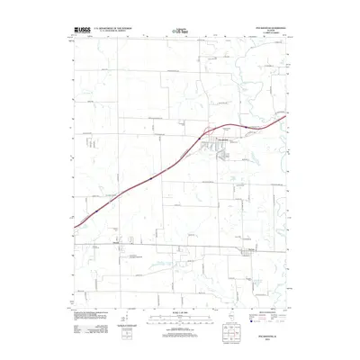
2012 Map of Pocahontas
USGS Topo · Published 2012About this map
Pocahontas and the smaller village of Pierron serve as the primary population centers in this Bond County landscape, where the flat agricultural plains are carved by the winding course of Shoal Cr and its tributaries like Locust Fork. The town of Pocahontas is centered around a grid of streets including Academy St and Railroad St, while historical memory is preserved in a high density of rural burial grounds such as Robinson Cem, Sugg Number 1 Cem, and Saint Nicholas Cem. The map reveals a transition from traditional farming to specialized land use, seen in features like Doll's Orchard and the Old Ripley Oil Field to the north. Transportation and local industry are further represented by the presence of Compton Airport and Smith RLA Ultralight Flightpark, illustrating how the mid-twentieth-century rural economy integrated private aviation and localized resource extraction into its traditional agrarian roots.
Find a feature on this map
86 named features on this map. Tap any name to fly to it.
Don’t see what you’re looking for? This feature index may not catch every label — zoom into the map to look around manually.
Map Details
Editions of this 2012 Pocahontas Map
This is the sole edition of this map. No revisions or reprints were ever made.
Other maps of this area

1906 · Breese
USGS Topo · 1:62,500

1907 · Breese
USGS Topo · 1:62,500

1910 · Carlyle
USGS Topo · 1:62,500

1932 · Greenville
USGS Topo · 1:62,500

1937 · New Douglas
USGS Topo · 1:48,000

1939 · Greenville
USGS Topo · 1:62,500

1943 · Greenville
USGS Topo · 1:62,500

1944 · New Douglas
USGS Topo · 1:62,500

1948 · Carlyle
USGS Topo · 1:62,500
1957 · Highland
USGS Topo · 1:24,000