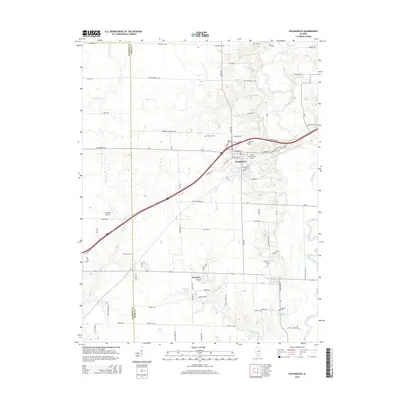
2015 Map of Pocahontas
USGS Topo · Published 2015About this map
Shoal Creek meanders through the eastern portion of this landscape, defining the rural character of the border between Madison and Bond counties. The village of Pocahontas serves as a central hub, where the Old National Trail Rd and N Frontage Ave intersect with the modern highway system. This area is notably dense with family and local history markers, featuring numerous small burial grounds such as Sugg Number 1 Cem, File Cem, and Robinson Cem. To the south, the village of Pierron sits near Potthast Lake and Locust Fork. The presence of Compton Airport and various named local routes like Cox Monument Ave provide specific landmarks for genealogists and local historians tracing property lines and community development in this part of Illinois.
Find a feature on this map
78 named features on this map. Tap any name to fly to it.
Don’t see what you’re looking for? This feature index may not catch every label — zoom into the map to look around manually.
Map Details
Editions of this 2015 Pocahontas Map
This is the sole edition of this map. No revisions or reprints were ever made.
Other maps of this area

1906 · Breese
USGS Topo · 1:62,500

1907 · Breese
USGS Topo · 1:62,500

1910 · Carlyle
USGS Topo · 1:62,500

1932 · Greenville
USGS Topo · 1:62,500

1937 · New Douglas
USGS Topo · 1:48,000

1939 · Greenville
USGS Topo · 1:62,500

1943 · Greenville
USGS Topo · 1:62,500

1944 · New Douglas
USGS Topo · 1:62,500

1948 · Carlyle
USGS Topo · 1:62,500
1957 · Highland
USGS Topo · 1:24,000