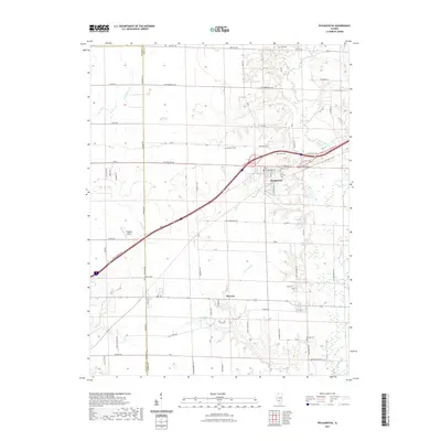
2021 Map of Pocahontas
USGS Topo · Published 2021About this map
The settlement of Pocahontas serves as the focal point of this Bond County landscape, situated where the historic E Old National Trl and E National St meet the modern corridors of Interstate 70. The village is flanked by several family and parish landmarks, including Sugg Cem and Saint Nicholas Cem. To the south, the village of Pierron sits near the winding course of Locust Fork, while the western edge of the quadrangle is defined by the Madison Co Bond Co line. A high density of cemeteries like File Cem, Robinson Cem, and Hug Cem indicates a long-settled rural community, with family names preserved in many local thoroughfares such as Niggli Rd and Cox Monument Ave. The area transitions from the small municipal grid to open fields and woodland buffers surrounding Sugar Cr and Shoal Creek.
Find a feature on this map
68 named features on this map. Tap any name to fly to it.
Don’t see what you’re looking for? This feature index may not catch every label — zoom into the map to look around manually.
Map Details
Editions of this 2021 Pocahontas Map
This is the sole edition of this map. No revisions or reprints were ever made.
Other maps of this area

1906 · Breese
USGS Topo · 1:62,500

1907 · Breese
USGS Topo · 1:62,500

1910 · Carlyle
USGS Topo · 1:62,500

1932 · Greenville
USGS Topo · 1:62,500

1937 · New Douglas
USGS Topo · 1:48,000

1939 · Greenville
USGS Topo · 1:62,500

1943 · Greenville
USGS Topo · 1:62,500

1944 · New Douglas
USGS Topo · 1:62,500

1948 · Carlyle
USGS Topo · 1:62,500
1957 · Highland
USGS Topo · 1:24,000