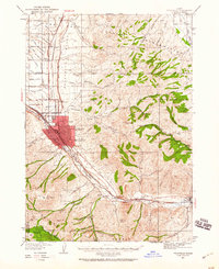
1937 Map of Pocatello
USGS Topo · Published 1960About this map
The Union Pacific railroad corridor serves as the industrial spine of this mid-1930s landscape, connecting the growing urban centers of Pocatello and Alameda with outlying agricultural and mountain districts. At the heart of the city, the University of Idaho Southern Branch and the County Fairgrounds stand as prominent landmarks. To the north, the Fort Hall Indian Reservation is defined by a dense network of irrigation features like Church Lateral Road and Wasteway Road, reflecting the intensive water management required for farming the Pocatello Bench.
Find a feature on this map
67 named features on this map. Tap any name to fly to it.
Don’t see what you’re looking for? This feature index may not catch every label — zoom into the map to look around manually.
Map Details
Editions of this 1937 Pocatello Map
3 editions found
Other maps of this area

1934 · Michaud
USGS Topo · 1:62,500

1937 · Pocatello
USGS Topo · 1:48,000

1937 · Michaud
USGS Topo · 1:62,500

1938 · Pauline
USGS Topo · 1:48,000

1940 · Blackfoot
USGS Topo · 1:62,500

1943 · Blackfoot
USGS Topo · 1:62,500

1944 · Pocatello
USGS Topo · 1:62,500

1944 · Arbon
USGS Topo · 1:62,500

1954 · Pocatello
USGS Topo · 1:250,000

1955 · Yandell Springs
USGS Topo · 1:62,500