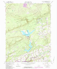
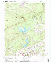
1960 Map of Pohopco Mountain
USGS Topo · Published 1984About this map
Penn Forest and the ridges of Pohopco Mountain dominate this mid-century portrait of Carbon and Monroe Counties. The landscape is defined by the management of water and timber, featuring the sprawling Penn Forest Reservoir and the Wild Creek Reservoir. These man-made features are bounded by the steep terrain of Call Mountain and the Stony Ridge, reflecting the era's focus on infrastructure and natural resource conservation within the Weiser State Forest.
Find a feature on this map
46 named features on this map. Tap any name to fly to it.
Don’t see what you’re looking for? This feature index may not catch every label — zoom into the map to look around manually.
Map Details
Editions of this 1960 Pohopco Mountain Map
5 editions found
Other maps of this area

1914 · Wind Gap
USGS Topo · 1:62,500

1916 · Wind Gap
USGS Topo · 1:62,500

1919 · Pocono
USGS Topo · 1:62,500

1921 · Pocono
USGS Topo · 1:62,500

1922 · Mauch Chunk
USGS Topo · 1:62,500

1922 · Stoddartsville
USGS Topo · 1:62,500

1923 · Pocono
USGS Topo · 1:62,500

1924 · Stoddartsville
USGS Topo · 1:62,500

1924 · Mauch Chunk
USGS Topo · 1:62,500

1943 · Scranton
USGS Topo · 1:125,000
Featured Places
- Towamensing Township, PA
- Eldred Township, PA
- Penn Forest Township, PA
- Tunkhannock Township, PA
- Indian Mountain Lake, PA