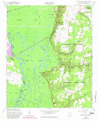
1953 Map of Poinsett State Park
USGS Topo · Published 1983About this map
Wateree Swamp dominates the western half of this landscape, where the meandering Wateree River forms the boundary between Richland and Sumter Counties. This 1953 survey, updated with 1980s photographic revisions, captures a region defined by the sharp contrast between the dense, lake-filled lowlands and the higher ground of Manchester State Forest to the east. The swamp is dotted with numerous named oxbows and pools like Big Lake and Holly Hill Lake, illustrating the complex hydrology of the Wateree basin before modern alterations. Along the rising bluffs, signs of early habitation and community life appear, including the Melrose Historical Home and local landmarks like Orange Hill Church. The infrastructure of the era is evident in the Southern Railway crossing the wetlands and the presence of the Lumber Camp, highlighting the timber and transport industries that shaped this part of South Carolina.
Find a feature on this map
55 named features on this map. Tap any name to fly to it.
Don’t see what you’re looking for? This feature index may not catch every label — zoom into the map to look around manually.
Map Details
Editions of this 1953 Poinsett State Park Map
4 editions found
Other maps of this area

1943 · Eastover
USGS Topo · 1:62,500

1946 · Elloree
USGS Topo · 1:62,500

1946 · Sumter
USGS Topo · 1:62,500

1953 · Poinsett State Park
USGS Topo · 1:24,000

1953 · Eastover
USGS Topo · 1:24,000

1953 · Wedgefield
USGS Topo · 1:24,000

1953 · Wateree
USGS Topo · 1:24,000

1954 · Augusta
USGS Topo · 1:250,000

1957 · Sumter West
USGS Topo · 1:24,000

1957 · Sumter
USGS Topo · 1:62,500