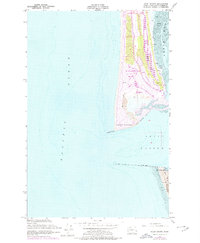
1955 Map of Point Brown
USGS Topo · Published 1978About this map
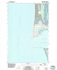
Ocean Shores and the surrounding Point Brown peninsula are caught in a period of significant coastal transformation on this survey, which includes 1973 revisions. The emerging street patterns of the community appear alongside expansive Sand Dunes and the prominent Duck Lake, illustrating the early stages of large-scale resort development on the Washington coast. At the entrance to Grays Harbor, massive engineering works like the North Jetty and the Submerged Jetty define the mouth of the harbor, while the Coast Guard Reservation sits across the channel at Pt Chehalis. The map meticulously details the surrounding Tidal Flat areas and North Bay, providing a clear view of the shifting sands and maritime infrastructure that shaped the region during the mid-20th century.
Find a feature on this map
24 named features on this map. Tap any name to fly to it.
Don’t see what you’re looking for? This feature index may not catch every label — zoom into the map to look around manually.
Map Details
Editions of this 1955 Point Brown Map
6 editions found
Other maps of this area

1938 · Moclips
USGS Topo · 1:62,500

1941 · Moclips
USGS Topo · 1:62,500

1941 · Grayland
USGS Topo · 1:62,500

1943 · Copalis Beach
USGS Topo · 1:250,000

1951 · Copalis Beach
USGS Topo · 1:250,000

1955 · Point Brown
USGS Topo · 1:24,000

1955 · Copalis Beach
USGS Topo · 1:24,000

1956 · Copalis Crossing
USGS Topo · 1:24,000
1956 · Westport
USGS Topo · 1:24,000
1956 · Grayland
USGS Topo · 1:24,000