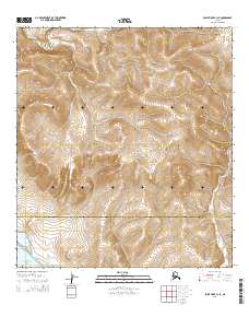
2014 Map of Point Hope A-1 SE
USGS Topo · Published 2014About this map
Chukchi Sea shoreline and tidal systems define this Arctic coastal region where the North Slope Borough Northwest Arctic Borough line cuts across the landscape. The hydrography is dominated by the winding course of the Kukpuk River in the north and the brackish waters of Singoalik Lagoon and Pusigrak Lagoon along the southern coast. These lagoons provide a look at the shifting interface between freshwater runoff and the sea, which is essential for understanding subsistence patterns and seasonal travel in the region. Inland, the terrain rises toward Tinguk Ridge, a prominent landform that breaks the coastal plain and provides a natural vantage point over the surrounding tundra and wetlands.
Find a feature on this map
12 named features on this map. Tap any name to fly to it.
Don’t see what you’re looking for? This feature index may not catch every label — zoom into the map to look around manually.
Map Details
Editions of this 2014 Point Hope A-1 SE Map
This is the sole edition of this map. No revisions or reprints were ever made.
Other maps of this area

1951 · De Long Mountains
USGS Topo · 1:250,000

1951 · Noatak
USGS Topo · 1:250,000

1952 · Point Hope
USGS Topo · 1:250,000
1952 · Noatak D-7
USGS Topo · 1:63,360

1955 · Noatak
USGS Topo · 1:250,000

1955 · De Long Mountains
USGS Topo · 1:250,000

1955 · Point Hope
USGS Topo · 1:250,000

1955 · Point Hope A-1
USGS Topo · 1:63,360
1955 · Noatak D-6
USGS Topo · 1:63,360
1955 · De Long Mountains A-5
USGS Topo · 1:63,360