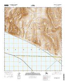
2014 Map of Point Hope A-1 SW
USGS Topo · Published 2014About this map
The Chukchi Sea coastline meets a landscape of significant coastal lagoons and sharp elevation changes in this North Slope region. The drainage patterns are defined by several named watercourses including Kukpak Cr, Kisimilok Cr, and Mapsorak Cr, which carve through the terrain toward the shore. A complex of lagoon systems, notably Atosik Lagoon, Mapsorak Lagoon, and Pusigrak Lagoon, forms a transition between the tundra and the sea. High points such as Kisimilok Mountain, Mapsorak Mountain, and Talaverat Hill provide vertical relief above the broad Kugukpak Valley. The survey also marks the administrative boundary between the North Slope Borough and Northwest Arctic Borough, illustrating how these political divisions intersect the natural geography of the Arctic coast.
Find a feature on this map
21 named features on this map. Tap any name to fly to it.
Don’t see what you’re looking for? This feature index may not catch every label — zoom into the map to look around manually.
Map Details
Editions of this 2014 Point Hope A-1 SW Map
This is the sole edition of this map. No revisions or reprints were ever made.
Other maps of this area

1951 · Noatak
USGS Topo · 1:250,000

1952 · Point Hope
USGS Topo · 1:250,000
1952 · Noatak D-7
USGS Topo · 1:63,360

1952 · Point Hope A-2
USGS Topo · 1:63,360

1955 · Noatak
USGS Topo · 1:250,000

1955 · Point Hope
USGS Topo · 1:250,000

1955 · Point Hope A-1
USGS Topo · 1:63,360

1964 · Noatak
USGS Topo · 1:250,000

1965 · Point Hope
USGS Topo · 1:250,000
2014 · Point Hope A-2 SE
USGS Topo · 1:25,000