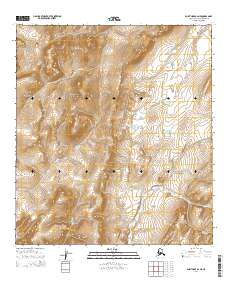
2014 Map of Point Hope A-2 NE
USGS Topo · Published 2014About this map
Kemegrak Hills rise in the northwest corner of this North Slope landscape, defining a complex drainage system that feeds into the Chukchi Sea. The terrain is structured by prominent elevations including Saligvik Ridge and Stoney Ridge, which separate the lower drainage basins of Saligvik Cr and Ogotoruk Cr. In the central portion of the quadrangle, Saligvik Valley opens up near the shores of Ikaknak Pond, while the broader Ogotoruk Valley dominates the southeastern quadrant. This 2014 survey reveals a transition from sharp ridgelines to tundra wetlands, where small water bodies like Pumaknak Pond sit between the heights of Guard Hill and Flag Hill. The dense network of creeks, including Ilikrak Cr and Kiliguak Cr, illustrates the intricate flow of seasonal meltwater through the Arctic permafrost.
Find a feature on this map
27 named features on this map. Tap any name to fly to it.
Don’t see what you’re looking for? This feature index may not catch every label — zoom into the map to look around manually.
Map Details
Editions of this 2014 Point Hope A-2 NE Map
This is the sole edition of this map. No revisions or reprints were ever made.
Other maps of this area

1952 · Point Hope
USGS Topo · 1:250,000

1952 · Point Hope A-2
USGS Topo · 1:63,360

1955 · Point Hope
USGS Topo · 1:250,000

1955 · Point Hope A-1
USGS Topo · 1:63,360

1955 · Point Hope B-1
USGS Topo · 1:63,360

1955 · Point Hope B-2
USGS Topo · 1:63,360

1965 · Point Hope
USGS Topo · 1:250,000
2014 · Point Hope A-2 SE
USGS Topo · 1:25,000
2014 · Point Hope A-2 SW
USGS Topo · 1:25,000
2014 · Point Hope A-1 SW
USGS Topo · 1:25,000