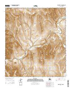
2014 Map of Point Hope B-1 NW
USGS Topo · Published 2014About this map
The Maktak Mountain region of the North Slope presents a landscape defined by dramatic elevation changes and a network of arterial waterways. The Ipewik River snakes through the southern and central sections of the sheet, providing a primary drainage route for the high country. To the west, the Lisburne Hills rise sharply, while the drainage of Tukingurok Cr cuts through the center of the quadrangle. This area is characterized by its isolation and the absence of established road infrastructure or permanent settlements, showcasing the terrain of the Alaskan Arctic in the early 21st century. Smaller watercourses like Uyakturok Cr drain the northern slopes, illustrating the complex hydrology of this part of the Brooks Range foothills.
Find a feature on this map
9 named features on this map. Tap any name to fly to it.
Don’t see what you’re looking for? This feature index may not catch every label — zoom into the map to look around manually.
Map Details
Editions of this 2014 Point Hope B-1 NW Map
This is the sole edition of this map. No revisions or reprints were ever made.
Other maps of this area

1952 · Point Hope
USGS Topo · 1:250,000

1955 · Point Hope
USGS Topo · 1:250,000

1955 · Point Hope C-1
USGS Topo · 1:63,360

1955 · Point Hope B-1
USGS Topo · 1:63,360

1955 · Point Hope C-2
USGS Topo · 1:63,360

1955 · Point Hope B-2
USGS Topo · 1:63,360

1965 · Point Hope
USGS Topo · 1:250,000
2014 · Point Hope C-1 SW
USGS Topo · 1:25,000
2014 · Point Hope B-1 NE
USGS Topo · 1:25,000
2014 · Point Hope B-2 SE
USGS Topo · 1:25,000