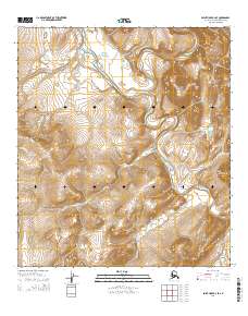
2014 Map of Point Hope B-2 SE
USGS Topo · Published 2014About this map
Kayaksak Mountain and Igilerak Hill dominate the topography of this remote landscape in the North Slope Borough, where elevation changes are defined by narrow creek valleys and rising ridges. The Kukpuk River snakes through the central terrain, serving as the primary hydrological artery fed by numerous tributaries including Ilikrak Cr and Kokirat Cr. This environment is characterized by its drainage patterns, notably where the Ipewik River enters the frame from the north. The southern portion of the sheet is marked by the prominent Saligvik Ridge, which overlooks the headwaters of Saligvik Cr and Angmakrok Cr. The map preserves the indigenous nomenclature of these landforms and waterways, providing a precise record of the geographic naming conventions used by the U.S. Geological Survey in this Arctic region.
Find a feature on this map
15 named features on this map. Tap any name to fly to it.
Don’t see what you’re looking for? This feature index may not catch every label — zoom into the map to look around manually.
Map Details
Editions of this 2014 Point Hope B-2 SE Map
This is the sole edition of this map. No revisions or reprints were ever made.
Other maps of this area

1952 · Point Hope
USGS Topo · 1:250,000

1952 · Point Hope A-2
USGS Topo · 1:63,360

1955 · Point Hope
USGS Topo · 1:250,000

1955 · Point Hope A-1
USGS Topo · 1:63,360

1955 · Point Hope B-1
USGS Topo · 1:63,360

1955 · Point Hope B-2
USGS Topo · 1:63,360

1965 · Point Hope
USGS Topo · 1:250,000
2014 · Point Hope B-2 NW
USGS Topo · 1:25,000
2014 · Point Hope A-1 NW
USGS Topo · 1:25,000
2014 · Point Hope A-2 NW
USGS Topo · 1:25,000