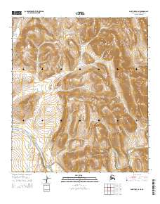
2014 Map of Point Hope B-2 NE
USGS Topo · Published 2014About this map
Mount Niaktuvik and the Lisburne Hills dominate this portion of the North Slope, where the drainage systems define the high Arctic landscape. The Kukpuk River winds through the southern section of the quadrangle, joined by tributaries like Ogsachak Cr and Iaruivotalik Cr. This 2014 survey illustrates the complex topography surrounding Ogsachak Mountain, providing a detailed view of the watercourses that have historically shaped movement through this region. The northern reaches are marked by the headwaters of Kugirakok Cr and Igruivotalik Cr, while the eastern edge is defined by the Tukingakok Cr and the Ipewik River. The map primarily documents the natural hydrology and elevation of the Alaska wilderness, highlighting the isolation and scale of these named features within the North Slope Borough.
Find a feature on this map
14 named features on this map. Tap any name to fly to it.
Don’t see what you’re looking for? This feature index may not catch every label — zoom into the map to look around manually.
Map Details
Editions of this 2014 Point Hope B-2 NE Map
This is the sole edition of this map. No revisions or reprints were ever made.
Other maps of this area

1952 · Point Hope
USGS Topo · 1:250,000

1955 · Point Hope
USGS Topo · 1:250,000

1955 · Point Hope C-1
USGS Topo · 1:63,360

1955 · Point Hope B-1
USGS Topo · 1:63,360

1955 · Point Hope C-2
USGS Topo · 1:63,360

1955 · Point Hope B-2
USGS Topo · 1:63,360

1965 · Point Hope
USGS Topo · 1:250,000
2014 · Point Hope B-2 NW
USGS Topo · 1:25,000
2014 · Point Hope C-1 SW
USGS Topo · 1:25,000
2014 · Point Hope B-2 SE
USGS Topo · 1:25,000