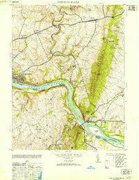
1953 Map of Point Of Rocks
USGS Topo · Published 1953About this map
The Potomac River corridor serves as the central artery for this mid-century survey, defining the border between Frederick County, Maryland, and Loudoun County, Virginia. The landscape is dominated by the linear industrial and transportation paths of the Baltimore and Ohio railroad and the Chesapeake and Ohio Canal, which parallel the river's northern bank. Significant river features like Heaters Island and Paton I are charted near the village of Point of Rocks, while the steep slopes of Catoctin Mountain rise abruptly to the east. The map records a transition from the dense rail yards at Brunswick to scattered agrarian settlements and milling sites, such as Bells Mill on Catoctin Creek. Local social geography is anchored by rural landmarks including St Marks Church and the small community of Slabtown.
Find a feature on this map
32 named features on this map. Tap any name to fly to it.
Don’t see what you’re looking for? This feature index may not catch every label — zoom into the map to look around manually.
Map Details
Editions of this 1953 Point Of Rocks Map
2 editions found
Other maps of this area

1884 · Harpers Ferry
USGS Topo · 1:125,000

1891 · Harpers Ferry
USGS Topo · 1:125,000

1893 · Frederick
USGS Topo · 1:125,000

1893 · Harpers Ferry
USGS Topo · 1:125,000

1894 · Frederick
USGS Topo · 1:125,000

1908 · Middletown
USGS Topo · 1:48,000

1908 · Seneca
USGS Topo · 1:62,500

1908 · Ijamsville
USGS Topo · 1:62,500

1909 · Ijamsville
USGS Topo · 1:62,500

1910 · Antietam
USGS Topo · 1:62,500