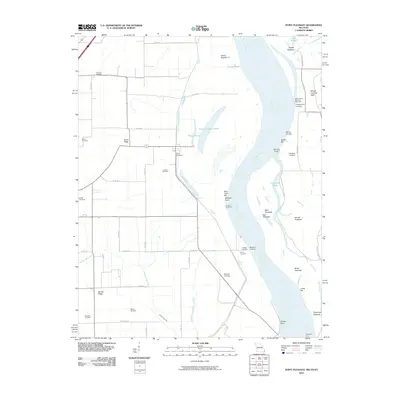
2010 Map of Point Pleasant
USGS Topo · Published 2010About this map
The Mississippi River meanders through this portion of the Missouri Bootheel, defining a landscape of shifting channels, towheads, and river landings. In the first decade of the 21st century, the river's influence is clear through features like Toneys Chute, Point Pleasant Chute, and Tiptonville Chute. These waterways isolate landforms such as Island Number 11 and the prominent Slough Landing Neck. This map is particularly valuable for genealogical research, documenting numerous family-named burial sites including Le Sieur Cemetery, Yount Cemetery, and Creviosur Cemetery. The local economy and transport history are represented by traditional river access points such as Darnall Landing, Batesell Landing, and the Tiptonville Ferry crossing. Inland, the terrain is marked by Scrub Ridge and Barnes Ridge, while Portage Open Bay cuts through the low-lying plains west of the river.
Find a feature on this map
56 named features on this map. Tap any name to fly to it.
Don’t see what you’re looking for? This feature index may not catch every label — zoom into the map to look around manually.
Map Details
Editions of this 2010 Point Pleasant Map
This is the sole edition of this map. No revisions or reprints were ever made.
Other maps of this area

1925 · Reelfoot Lake
USGS Topo · 1:62,500

1939 · Reelfoot Lake
USGS Topo · 1:62,500

1939 · Portageville
USGS Topo · 1:62,500

1939 · New Madrid
USGS Topo · 1:62,500

1939 · Bayouville
USGS Topo · 1:62,500

1951 · New Madrid SE
USGS Topo · 1:24,000

1951 · Hubbard Lake
USGS Topo · 1:24,000

1954 · New Madrid
USGS Topo · 1:62,500

1955 · Portageville
USGS Topo · 1:62,500

1955 · Bayouville
USGS Topo · 1:62,500