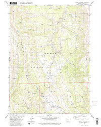
1980 Map of Poison Meadows
USGS Topo · Published 1980About this map
Tri Basin Divide serves as a critical hydrological and historical point within the Bridger National Forest. This high country is defined by the convergence of major drainage systems, including the Greys River flowing north and La Barge Creek moving south. Historically significant paths intersect here, most notably the Emigrant Trail and its associated Lander Cutoff, which provided westward travelers a vital route through the mountains. The presence of the La Barge Guard Sta and the Gaging Sta on Lander Cutoff Creek reflects a landscape managed for both preservation and resource monitoring. From the heights of Commissary Ridge to the secluded Poison Meadows, the map captures a network of legacy pack trails like the Wyoming Range Trail, once essential for navigating this remote corner of Lincoln County.
Find a feature on this map
37 named features on this map. Tap any name to fly to it.
Don’t see what you’re looking for? This feature index may not catch every label — zoom into the map to look around manually.
Map Details
Editions of this 1980 Poison Meadows Map
2 editions found
Other maps of this area

1921 · Afton
USGS Topo · 1:125,000

1936 · Cokeville
USGS Topo · 1:96,000

1942 · Cokeville
USGS Topo · 1:125,000

1955 · Preston
USGS Topo · 1:250,000

1958 · Preston
USGS Topo · 1:250,000

1962 · Preston
USGS Topo · 1:250,000

1967 · Graham Peak
USGS Topo · 1:24,000

1967 · Porcupine Creek
USGS Topo · 1:24,000

1967 · Mount Thompson
USGS Topo · 1:24,000
1980 · Mount Schidler
USGS Topo · 1:24,000