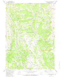
1980 Map of Poison Meadows
USGS Topo · Published 1980About this map
Commissary Ridge dominates this high-country landscape within the Bridger National Forest, serving as a significant geographical spine where multiple major drainage systems diverge. The map documents the critical intersection of the Lander Cutoff and the Emigrant Trail, historic corridors that guided westward travelers through the Wyoming wilderness. The Tri Basin Divide represents a rare hydrological point where water flows toward three different major basins, a feature of immense interest to early surveyors and scouts. Along the southern reaches, La Barge Creek meanders through La Barge Meadows near the La Barge Guard Sta, while the northern portion is defined by the headwaters of the Greys River and Clear Creek. The network of names like Wagner Pass and the Lookout Pack Trail illustrates the era's reliance on established mountain passes and pack routes for traversing this complex terrain.
Find a feature on this map
33 named features on this map. Tap any name to fly to it.
Don’t see what you’re looking for? This feature index may not catch every label — zoom into the map to look around manually.
Map Details
Editions of this 1980 Poison Meadows Map
2 editions found
Other maps of this area

1921 · Afton
USGS Topo · 1:125,000

1936 · Cokeville
USGS Topo · 1:96,000

1942 · Cokeville
USGS Topo · 1:125,000

1955 · Preston
USGS Topo · 1:250,000

1958 · Preston
USGS Topo · 1:250,000

1962 · Preston
USGS Topo · 1:250,000

1967 · Graham Peak
USGS Topo · 1:24,000

1967 · Porcupine Creek
USGS Topo · 1:24,000

1967 · Mount Thompson
USGS Topo · 1:24,000
1980 · Mount Schidler
USGS Topo · 1:24,000