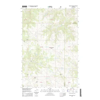
2017 Map of Poker Jim Butte
USGS Topo · Published 2017About this map
Custer National Forest encompasses the high country of the Wolf Mountains along the Rosebud and Powder River county line. This upland landscape is defined by its complex network of springs and reservoirs, such as the Experimental Pasture Reservoir and Parrish Spring-Poker Jim Reservoir, which supported the livestock and land management practices of the mid-20th century. High points like Poker Jim Butte and Horse Creek Buttes dominate the skyline, while deep-cut drainages including Sawmill Gulch and Griffin Gulch reveal the erosional patterns of the drainage basin for E Fork Hanging Woman Creek. The abundance of named water sources like Emma Kraft Springs and Jackson Sawmill Spring suggests a history of localized ranching operations and forestry within this portion of the national forest, where water security was paramount for sustaining life and industry.
Find a feature on this map
53 named features on this map. Tap any name to fly to it.
Don’t see what you’re looking for? This feature index may not catch every label — zoom into the map to look around manually.
Map Details
Editions of this 2017 Poker Jim Butte Map
This is the sole edition of this map. No revisions or reprints were ever made.
Other maps of this area

1954 · Hardin
USGS Topo · 1:250,000

1957 · Hardin
USGS Topo · 1:250,000

1958 · Hardin
USGS Topo · 1:250,000

1966 · Browns Mountain
USGS Topo · 1:24,000

1966 · Birney Day School
USGS Topo · 1:24,000

1966 · Poker Jim Butte
USGS Topo · 1:24,000

1966 · Fort Howes
USGS Topo · 1:24,000

1966 · King Mountain
USGS Topo · 1:24,000
1966 · Green Creek
USGS Topo · 1:24,000
1972 · Stroud Creek
USGS Topo · 1:24,000