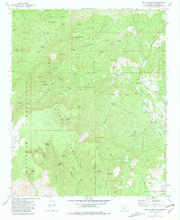
1975 Map of Poland Junction
USGS Topo · Published 1981About this map
Prescott National Forest serves as the backdrop for a landscape defined by its mining heritage and rugged topography in the mid-1970s. The Bradshaw Mountains and the flat-topped Big Bug Mesa dominate the terrain, separated by a complex network of canyons and gulches. The settlement of Walker and the transportation hub at Poland Junction are connected by remnants of the mining industry, most notably the Poland-Walker Tunnel. Numerous workings such as the Henrietta Mine, King Benjamin Mine, and Eugene Mine are scattered throughout the hills, many accompanied by dredge tailings along the watercourses. Water sources like Postmaster Spring and Grapevine Springs were vital in this arid environment, supporting both the mining operations and the scattered homesteads indicated by family-named landmarks like Chaparral and Ticonderoga.
Find a feature on this map
68 named features on this map. Tap any name to fly to it.
Don’t see what you’re looking for? This feature index may not catch every label — zoom into the map to look around manually.
Map Details
Editions of this 1975 Poland Junction Map
4 editions found
Other maps of this area

1887 · Prescott
USGS Topo · 1:250,000

1892 · Prescott
USGS Topo · 1:250,000

1903 · Bradshaw Mountains
USGS Topo · 1:125,000

1905 · Jerome
USGS Topo · 1:125,000

1944 · Mingus Mountain
USGS Topo · 1:62,500

1947 · Mingus Mtn
USGS Topo · 1:62,500

1947 · Mayer
USGS Topo · 1:62,500

1947 · Mt. Union
USGS Topo · 1:62,500

1947 · Prescott
USGS Topo · 1:62,500

1948 · Mt. Union
USGS Topo · 1:63,360