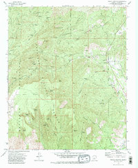
1975 Map of Poland Junction
USGS Topo · Published 1981About this map
Bradshaw Mountains mining history is etched into this mid-1970s survey, showing a landscape defined by industrial extraction and rugged western terrain. The area between Walker and Poland Junction is riddled with legacy workings, from the Ticonderoga Mine and Henrietta Mine to the subterranean passage of the Poland-Walker Tunnel. This network of shafts and dumps reflects a peak era of mineral pursuit, where remote operations like the King Benjamin Mine and Amulet Mine Dump were connected by a web of jeep trails and a former railroad grade.
Find a feature on this map
73 named features on this map. Tap any name to fly to it.
Don’t see what you’re looking for? This feature index may not catch every label — zoom into the map to look around manually.
Map Details
Editions of this 1975 Poland Junction Map
4 editions found
Other maps of this area

1887 · Prescott
USGS Topo · 1:250,000

1892 · Prescott
USGS Topo · 1:250,000

1903 · Bradshaw Mountains
USGS Topo · 1:125,000

1905 · Jerome
USGS Topo · 1:125,000

1944 · Mingus Mountain
USGS Topo · 1:62,500

1947 · Mingus Mtn
USGS Topo · 1:62,500

1947 · Mayer
USGS Topo · 1:62,500

1947 · Mt. Union
USGS Topo · 1:62,500

1947 · Prescott
USGS Topo · 1:62,500

1948 · Mt. Union
USGS Topo · 1:63,360