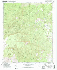
1975 Map of Poland Junction
USGS Topo · Published 1981About this map
Prescott National Forest dominates this mid-1970s topographical record, which captures the industrial footprint of Yavapai County's mining heritage. The landscape is heavily marked by gold and silver prospects, with clusters of Dredge Tailings along Big Bug Creek and Galena Gulch testifying to intensive riparian processing. Higher in the Bradshaw Mountains, the map details a network of shafts and tunnels including the King Benjamin Mine, the Henrietta Mine, and the Amulet Mine Dump. The settlement of Walker and the railroad-linked Poland Junction serve as the primary human hubs in this steep terrain. Genealogical interest is anchored by a local Cem and family-named landmarks like Mt Elliott and Eugene Ridge, while the extensive system of named springs like Postmaster Spring and Chaparral Spring highlights the critical importance of water sources in the high desert high-country.
Find a feature on this map
63 named features on this map. Tap any name to fly to it.
Don’t see what you’re looking for? This feature index may not catch every label — zoom into the map to look around manually.
Map Details
Editions of this 1975 Poland Junction Map
4 editions found
Other maps of this area

1887 · Prescott
USGS Topo · 1:250,000

1892 · Prescott
USGS Topo · 1:250,000

1903 · Bradshaw Mountains
USGS Topo · 1:125,000

1905 · Jerome
USGS Topo · 1:125,000

1944 · Mingus Mountain
USGS Topo · 1:62,500

1947 · Mingus Mtn
USGS Topo · 1:62,500

1947 · Mayer
USGS Topo · 1:62,500

1947 · Mt. Union
USGS Topo · 1:62,500

1947 · Prescott
USGS Topo · 1:62,500

1948 · Mt. Union
USGS Topo · 1:63,360