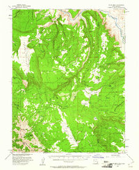
1954 Map of Polar Mesa
USGS Topo · Published 1961About this map
The Dolores River cuts a deep northern boundary through this high desert plateau, where the Manti-La Sal National Forest dominates the high-elevation terrain of the eastern La Sal Mountains. This mid-century survey was conducted with cooperation from the Atomic Energy Commission, reflecting an era of intense mineral interest in the Colorado Plateau. The landscape is defined by vast mesas like Polar Mesa and Beaver Mesa, which rise above deep drainage systems such as Cottonwood Canyon and Onion Creek. Evidence of land use is visible in the presence of a Grain Storage Tank near the north-central mesas and a network of Jeep Trails providing access across the remote flats of Taylor Flat and the dramatic depression of Sinbad Valley. Geologic landmarks such as Mt Waas and Manns Peak anchor the southwestern corner, marking the rugged transition toward the San Juan County line.
Find a feature on this map
42 named features on this map. Tap any name to fly to it.
Don’t see what you’re looking for? This feature index may not catch every label — zoom into the map to look around manually.
Map Details
Editions of this 1954 Polar Mesa Map
4 editions found

Other maps of this area

1885 · La Sal
USGS Topo · 1:250,000

1916 · Paradox Valley
USGS Topo · 1:125,000

1922 · Paradox Valley
USGS Topo · 1:125,000

1948 · Roc Creek
USGS Topo · 1:24,000

1949 · Roc Creek
USGS Topo · 1:24,000

1949 · Juanita Arch
USGS Topo · 1:24,000

1949 · Gateway
USGS Topo · 1:24,000

1950 · Juanita Arch
USGS Topo · 1:24,000

1952 · Gateway
USGS Topo · 1:24,000

1954 · Mt Peale 1 NE
USGS Topo · 1:24,000