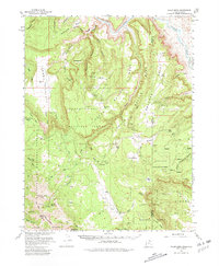
1954 Map of Polar Mesa
USGS Topo · Published 1981About this map
The Dolores River winds through the northern reaches of this mid-century survey, carving deep canyons that define the border between Utah and Colorado. Much of the landscape is dominated by the high plateaus of Polar Mesa and Beaver Mesa, which sit within the expansive Manti-La Sal National Forest. To the southwest, the dramatic rise of the La Sal Mountains is marked by prominent summits including Manns Peak and Mt Waas. The presence of a Grain Storage Tank on the mesa and scattered reservoirs near Kirks Basin indicates the area's use for high-altitude ranching and agriculture despite the isolated terrain. In the southeast, the geological anomaly of Sinbad Valley provides a distinct contrast to the surrounding mesa tops like Dolores Point, illustrating the complex drainage patterns of Deep Creek and Roc Creek.
Find a feature on this map
44 named features on this map. Tap any name to fly to it.
Don’t see what you’re looking for? This feature index may not catch every label — zoom into the map to look around manually.
Map Details
Editions of this 1954 Polar Mesa Map
4 editions found

Other maps of this area

1885 · La Sal
USGS Topo · 1:250,000

1916 · Paradox Valley
USGS Topo · 1:125,000

1922 · Paradox Valley
USGS Topo · 1:125,000

1948 · Roc Creek
USGS Topo · 1:24,000

1949 · Roc Creek
USGS Topo · 1:24,000

1949 · Juanita Arch
USGS Topo · 1:24,000

1949 · Gateway
USGS Topo · 1:24,000

1950 · Juanita Arch
USGS Topo · 1:24,000

1952 · Gateway
USGS Topo · 1:24,000

1954 · Mt Peale 1 NE
USGS Topo · 1:24,000