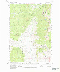
1959 Map of Polaris
USGS Topo · Published 1980About this map
Pioneer Mountains and the Big Hole Divide define the high-elevation landscape of this 1959 survey, where the extraction of mineral wealth meets early recreational tourism. The central valley of Grasshopper Creek serves as the primary artery for local life, anchoring the settlement of Polaris and its associated Polaris Sch. This area is characterized by a mix of active and historic industry, including the Old Elkhorn Mine, Magna Mine, and a Tungsten Mill.
Find a feature on this map
77 named features on this map. Tap any name to fly to it.
Don’t see what you’re looking for? This feature index may not catch every label — zoom into the map to look around manually.
Map Details
Editions of this 1959 Polaris Map
3 editions found
Other maps of this area

1893 · Dillon
USGS Topo · 1:250,000

1952 · Bannack
USGS Topo · 1:24,000

1952 · Torrey Mountain
USGS Topo · 1:24,000

1952 · Ermont
USGS Topo · 1:24,000

1955 · Dillon
USGS Topo · 1:250,000

1957 · Dillon
USGS Topo · 1:250,000

1958 · Dillon
USGS Topo · 1:250,000

1958 · Vipond Park
USGS Topo · 1:62,500

1959 · Polaris
USGS Topo · 1:62,500

1959 · Grant
USGS Topo · 1:62,500