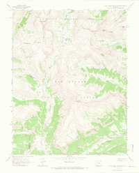
1964 Map of Pole Creek Mountain
USGS Topo · Published 1967About this map
Pole Creek Mountain stands at the center of this 1964 survey, where the high-altitude terrain of the Gunnison National Forest and Rio Grande National Forest meet. The Continental Divide winds across the northern half of the sheet, connecting prominent summits like Bent Peak and Carson Peak. This area is characterized by a high-country transportation network of specialized paths, including a Stock Driveway and several routes marked as Pack Trail or Jeep Trail, illustrating how the landscape was managed for grazing and backcountry access in the mid-20th century.
Find a feature on this map
27 named features on this map. Tap any name to fly to it.
Don’t see what you’re looking for? This feature index may not catch every label — zoom into the map to look around manually.
Map Details
Editions of this 1964 Pole Creek Mountain Map
4 editions found
Other maps of this area

1897 · Silverton
USGS Topo · 1:62,500

1900 · Needle Mountains
USGS Topo · 1:62,500

1901 · Silverton
USGS Topo · 1:62,500

1902 · Needle Mountains
USGS Topo · 1:62,500

1902 · Silverton
USGS Topo · 1:62,500

1905 · San Cristobal
USGS Topo · 1:125,000

1907 · San Cristobal
USGS Topo · 1:125,000

1945 · Durango
USGS Topo · 1:250,000

1953 · Durango
USGS Topo · 1:250,000

1954 · Durango
USGS Topo · 1:250,000