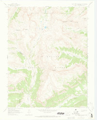
1964 Map of Pole Creek Mountain
USGS Topo · Published 1973About this map
The Continental Divide snake-curves through this high-altitude landscape, marking the boundary between the Gunnison National Forest and the Rio Grande National Forest. High peaks like Bent Peak, Carson Peak, and Pole Creek Mountain define the topography, with drainage patterns flowing toward major water systems like the Rio Grande and Cataract Lake.
Find a feature on this map
24 named features on this map. Tap any name to fly to it.
Don’t see what you’re looking for? This feature index may not catch every label — zoom into the map to look around manually.
Map Details
Editions of this 1964 Pole Creek Mountain Map
4 editions found
Other maps of this area

1897 · Silverton
USGS Topo · 1:62,500

1900 · Needle Mountains
USGS Topo · 1:62,500

1901 · Silverton
USGS Topo · 1:62,500

1902 · Needle Mountains
USGS Topo · 1:62,500

1902 · Silverton
USGS Topo · 1:62,500

1905 · San Cristobal
USGS Topo · 1:125,000

1907 · San Cristobal
USGS Topo · 1:125,000

1945 · Durango
USGS Topo · 1:250,000

1953 · Durango
USGS Topo · 1:250,000

1954 · Durango
USGS Topo · 1:250,000