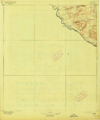
1896 Map of Polvo
USGS Topo · Published 1913About this map
The Rio Grande defines this 1895 survey of the Texas-Mexico borderlands, tracing the United States Mexico Boundary Line through the desert of Presidio County. This sparsely populated frontier landscape is anchored by riverside settlements like Polvo and Mulato, where the river provided a vital lifeline for small communities and livestock operations. The terrain to the northeast is defined by a series of deep drainages, including Bofecillos Canyon and Tapado Canyon, which cut through high mesas toward the river valley. Numerous family-named sites such as Burros Ranch and Ellozo Ranch are documented, suggesting a period of early ranching activity before the establishment of more modern regional infrastructure. The map provides a clear record of the early international border, marking the division between Texas and Chihuahua at the turn of the century.
Find a feature on this map
17 named features on this map. Tap any name to fly to it.
Don’t see what you’re looking for? This feature index may not catch every label — zoom into the map to look around manually.
Map Details
Editions of this 1896 Polvo Map
4 editions found
Other maps of this area

1896 · Ruidosa
USGS Topo · 1:125,000

1896 · Polvo
USGS Topo · 1:125,000

1896 · Shafter
USGS Topo · 1:125,000

1903 · Terlingua
USGS Topo · 1:125,000

1904 · Terlingua
USGS Topo · 1:125,000

1917 · Tascotal Mesa
USGS Topo · 1:62,500

1931 · Lajitas
USGS Topo · 1:62,500

1944 · Tascotal Mesa
USGS Topo · 1:62,500

1959 · Emory Peak
USGS Topo · 1:250,000

1959 · Presidio
USGS Topo · 1:250,000