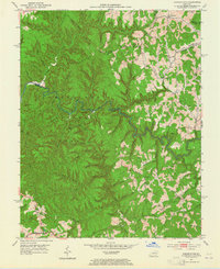
1951 Map of Pomeroyton
USGS Topo · Published 1965About this map
The winding course of the Red River carves through the central terrain of the Cumberland National Forest, marking the boundary between Menifee and Wolfe counties in the early 1950s. This survey captures a rural landscape where life centered on the narrow ridges and creek bottoms, evidenced by scattered community hubs like Pomeroyton and Valeria. The social fabric of the era is preserved in the location of several remote educational and religious sites, including the Calaboose Sch, Pine Branch Ch, and the Desie Scott Childrens Home near Pine Ridge.
Find a feature on this map
65 named features on this map. Tap any name to fly to it.
Don’t see what you’re looking for? This feature index may not catch every label — zoom into the map to look around manually.
Map Details
Editions of this 1951 Pomeroyton Map
2 editions found
Other maps of this area

1889 · Salyersville
USGS Topo · 1:125,000

1891 · Salyersville
USGS Topo · 1:125,000

1892 · Beattyville
USGS Topo · 1:125,000

1899 · Salyersville
USGS Topo · 1:125,000

1951 · Landsaw
USGS Topo · 1:24,000

1951 · Ezel
USGS Topo · 1:24,000

1951 · Hazel Green
USGS Topo · 1:24,000

1951 · Pomeroyton
USGS Topo · 1:24,000

1952 · Scranton
USGS Topo · 1:24,000

1952 · Frenchburg
USGS Topo · 1:24,000