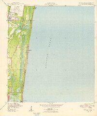
1949 Map of Pompano Beach
USGS Topo · Published 1949About this map
Pompano Beach and the burgeoning northern reaches of Fort Lauderdale define this coastal landscape just after the war. The map documents a critical era of South Florida development, where established rail lines like the Florida East Coast intersect with the Intracoastal Waterway and the Atlantic Ocean shoreline. Inland, the grid of Oakland Park and the specialized finger islands of Nurmi Isles show the early engineering of the marshlands into residential waterfronts.
Find a feature on this map
25 named features on this map. Tap any name to fly to it.
Don’t see what you’re looking for? This feature index may not catch every label — zoom into the map to look around manually.
Map Details
Editions of this 1949 Pompano Beach Map
2 editions found
Other maps of this area

1945 · Fort Lauderdale North
USGS Topo · 1:24,000

1946 · West Dixie Bend
USGS Topo · 1:24,000

1946 · Boca Raton
USGS Topo · 1:24,000

1949 · Fort Lauderdale North
USGS Topo · 1:24,000

1949 · West Dixie Bend
USGS Topo · 1:24,000

1949 · Port Everglades
USGS Topo · 1:24,000

1949 · Fort Lauderdale South
USGS Topo · 1:24,000

1949 · Pompano Beach
USGS Topo · 1:24,000

1950 · Boca Raton
USGS Topo · 1:24,000

1956 · West Palm Beach
USGS Topo · 1:250,000
Featured Places
- Fort Lauderdale, FL
- Pompano Beach, FL
- Lauderdale-by-the-Sea, FL
- Birch Ocean Front, Fort Lauderdale
- Sunrise Key, Fort Lauderdale