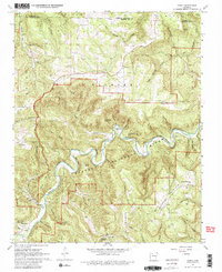
1967 Map of Ponca
USGS Topo · Published 1981About this map
The Buffalo River winds through a landscape defined by deep limestone bluffs and the steep ridges of the Ozarks in this 1967 survey. The settlement of Ponca serves as a focal point in the southwest, situated near the gateway to Lost Valley State Park and the rugged Leatherwood Creek. The map records the early years of the Buffalo National River designation, capturing a transition from agricultural use to federal preservation. High points like Sherman Mountain and Low Gap Mountain tower over the valley, while the presence of the Compton Lookout Tower and multiple mountain churches like Mountain Springs Ch and Phumlee Ch reflect a remote but established upland community. Small-scale mining and quarrying, indicated by Mines and a Quarry near Clark Creek, hint at the local extraction economy that predated the region's focus on conservation and tourism.
Find a feature on this map
76 named features on this map. Tap any name to fly to it.
Don’t see what you’re looking for? This feature index may not catch every label — zoom into the map to look around manually.
Map Details
Editions of this 1967 Ponca Map
3 editions found
Other maps of this area

1904 · Harrison
USGS Topo · 1:125,000

1905 · Harrison
USGS Topo · 1:125,000

1933 · Mt Judea
USGS Topo · 1:62,500

1940 · Mt Judea
USGS Topo · 1:62,500

1945 · Harrison
USGS Topo · 1:250,000

1949 · Harrison
USGS Topo · 1:250,000

1954 · Harrison
USGS Topo · 1:250,000

1956 · Russellville
USGS Topo · 1:250,000

1958 · Harrison
USGS Topo · 1:250,000

1964 · Russellville
USGS Topo · 1:250,000