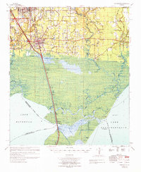
1969 Map of Ponchatoula
USGS Topo · Published 1971About this map
Illinois Central rails bisect this landscape, connecting the growing hubs of Hammond and Ponchatoula to the swampy reaches of Lake Maurepas and Lake Pontchartrain. The transition from the piney uplands to the coastal marsh is marked by an intricate network of waterways, including the Tangipahoa River, Natalbany River, and the strategic Pass Manchac, where the settlement of Manchac (Akers PO) stands on Jones Island. Grounded in the late 1960s, the map reveals a rural character defined by family-named landmarks and local institutions like the Champ Cooper Sch, Reeves Sch, and Wesley Chapel. Notable heritage sites such as Indian Mounds near Bedico Creek and cemeteries like Arnold Cem offer deep roots for researchers. The presence of the Industrial Railroad and various canals like the Anderson Canal reflects the region's reliance on timber and water-borne transport during this era.
Find a feature on this map
71 named features on this map. Tap any name to fly to it.
Don’t see what you’re looking for? This feature index may not catch every label — zoom into the map to look around manually.
Map Details
Editions of this 1969 Ponchatoula Map
This is the sole edition of this map. No revisions or reprints were ever made.
Other maps of this area

1891 · Spanish Fort
USGS Topo · 1:62,500

1892 · Mount Airy
USGS Topo · 1:62,500

1892 · Bonnet Carre
USGS Topo · 1:62,500

1934 · Springfield
USGS Topo · 1:62,500

1935 · Covington
USGS Topo · 1:62,500

1935 · Ponchatoula
USGS Topo · 1:62,500

1936 · Ruddock
USGS Topo · 1:31,680

1936 · Bonnet Carre
USGS Topo · 1:62,500

1936 · Spanish Fort
USGS Topo · 1:62,500

1939 · Ponchatoula
USGS Topo · 1:62,500