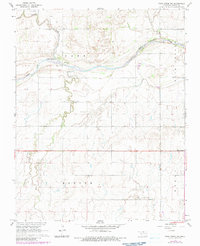
1968 Map of Pond Creek NW
USGS Topo · Published 1983About this map
The Salt Fork Arkansas River carves a winding path across this northern Oklahoma landscape, defining the northern border of Barr township. The river's braided channels and the prominent Rock Island illustrate the dynamic hydrology of the region before extensive modern channelization. Along the water, Hixson Bridge provides a key crossing point, while the Biby Landing Strip suggests the early importance of private aviation in managing these rural agricultural tracts.
Find a feature on this map
15 named features on this map. Tap any name to fly to it.
Don’t see what you’re looking for? This feature index may not catch every label — zoom into the map to look around manually.
Map Details
Editions of this 1968 Pond Creek NW Map
2 editions found
Other maps of this area

1955 · Enid
USGS Topo · 1:250,000

1955 · Woodward
USGS Topo · 1:250,000

1958 · Enid
USGS Topo · 1:250,000

1958 · Woodward
USGS Topo · 1:250,000

1968 · Hillsdale
USGS Topo · 1:24,000

1968 · Wakita SE
USGS Topo · 1:24,000

1968 · Kremlin
USGS Topo · 1:24,000

1968 · Pond Creek
USGS Topo · 1:24,000

1968 · Pond Creek NW
USGS Topo · 1:24,000

1968 · Wakita SW
USGS Topo · 1:24,000