
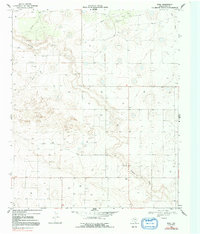
1969 Map of Pool
USGS Topo · Published 1971About this map
Sulphur Draw carves a winding path across this West Texas landscape, defining the topography of Terry County during the late 1960s. The small settlement of Pool serves as the central focal point of the quadrangle, situated amidst a grid of section lines and rural infrastructure typical of the Llano Estacado. The map reveals an area intensely developed for resource extraction and local transit, with numerous drill holes, pipelines, and oil wells scattered across the plains.
Find a feature on this map
7 named features on this map. Tap any name to fly to it.
Don’t see what you’re looking for? This feature index may not catch every label — zoom into the map to look around manually.
Map Details
Editions of this 1969 Pool Map
2 editions found
Other maps of this area

1954 · Brownfield
USGS Topo · 1:250,000

1958 · Brownfield
USGS Topo · 1:250,000

1962 · Brownfield
USGS Topo · 1:250,000

1965 · Sundown
USGS Topo · 1:24,000

1965 · Plains 1 NE
USGS Topo · 1:24,000

1965 · Lockettville
USGS Topo · 1:24,000

1969 · Gomez
USGS Topo · 1:24,000

1969 · Plains 1 SE
USGS Topo · 1:24,000

1969 · Sundown SE
USGS Topo · 1:24,000
1969 · Brownfield West
USGS Topo · 1:24,000