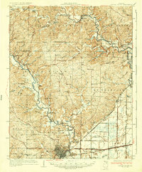
1935 Map of Poplar Bluff
USGS Topo · Published 1935About this map
Poplar Bluff serves as the focal point for this 1930s landscape, where the St Louis San Francisco and Missouri Pacific railroads converge amidst a network of small agricultural and river communities. The Black River and ST Francis River dominate the topography, carving through ridges like Barrett Ridge and Divide Ridge. This era shows a countryside densely dotted with neighborhood landmarks such as Oak Grove Ch, Pike Creek Ch, and the Hurley Cem, reflecting the decentralized social structure of Butler and Wayne counties before mid-century modernization.
Find a feature on this map
93 named features on this map. Tap any name to fly to it.
Don’t see what you’re looking for? This feature index may not catch every label — zoom into the map to look around manually.
Map Details
Editions of this 1935 Poplar Bluff Map
3 editions found
Other maps of this area

1932 · Piedmont
USGS Topo · 1:62,500

1934 · Greenville
USGS Topo · 1:62,500

1934 · Williamsville
USGS Topo · 1:48,000

1934 · Puxico
USGS Topo · 1:62,500

1935 · Poplar Bluff
USGS Topo · 1:62,500

1935 · Zalma
USGS Topo · 1:62,500

1935 · Piedmont
USGS Topo · 1:62,500

1935 · Acorn
USGS Topo · 1:62,500

1935 · Harviell
USGS Topo · 1:62,500

1939 · Greenville
USGS Topo · 1:62,500